

Picture this. A developer finds a promising lot. The numbers work. The location is strong. They’re ready to make an offer.
Then, right before closing, someone finally checks the fine print in the zoning code. There’s an overlay restriction nobody caught. It cuts the buildable space and changes the entire deal.
This happens more often than it should. Not because developers are careless, but because site selection has always relied on slow, manual research. Municipal codes. Zoning maps. PDFs. Phone calls to planning departments. It’s a process built for a much slower industry.
That’s changing. AI site selection tools now let developers, investors, and architects screen land in minutes instead of weeks. And the real advantage isn’t just speed. It’s finding better land, with fewer surprises, before anyone else even looks at it.
The Old Way: Why Manual Site Selection Costs Developers Time and Deals
Traditional site research means piecing together information from many places. A zoning ordinance here. A GIS map there. A call to a city planner to confirm a detail buried in a PDF from years ago.
This creates three real problems for developers.
Data fragmentation. Zoning rules, flood maps, ownership records, and easements all live in different systems. Nothing talks to each other. Every site becomes its own research project from scratch.
Human error. Overlay zones and conditional-use restrictions are easy to miss when you’re manually reading through dense legal language. A missed detail can turn a good deal into a costly mistake, sometimes not discovered until much later in the process.
No ability to scale. Because manual research takes so long, teams can only carefully review a handful of sites at a time. That means passing on opportunities simply due to lack of bandwidth, not lack of potential.
This is what “pre-development” research actually is: the work done before a developer commits capital to a site, to confirm what can legally and physically be built there. It’s essential. It’s also, traditionally, one of the slowest parts of the entire development process.
What AI Site Selection Software Actually Does
AI site selection tools don’t just digitize the old process. They change how the research gets done.
Zoning and Code Analysis
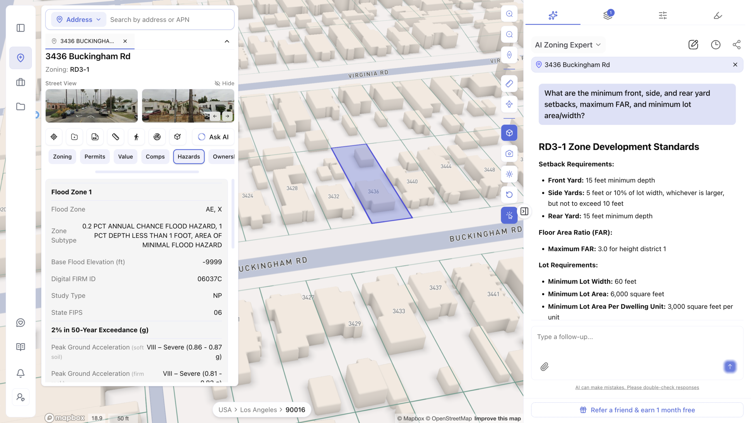
Zoning is the set of local rules that determine what can be built on a piece of land, including use type, height, and density. One key number inside zoning codes is FAR, or Floor Area Ratio. It’s a simple multiplier that determines how much building square footage is allowed based on the size of the lot.
Instead of just showing you a zoning map, AI tools read and interpret the actual code. They pull out setbacks, height limits, lot coverage rules, and whether a use is permitted outright or requires special approval.
Overlay and Setback Detection
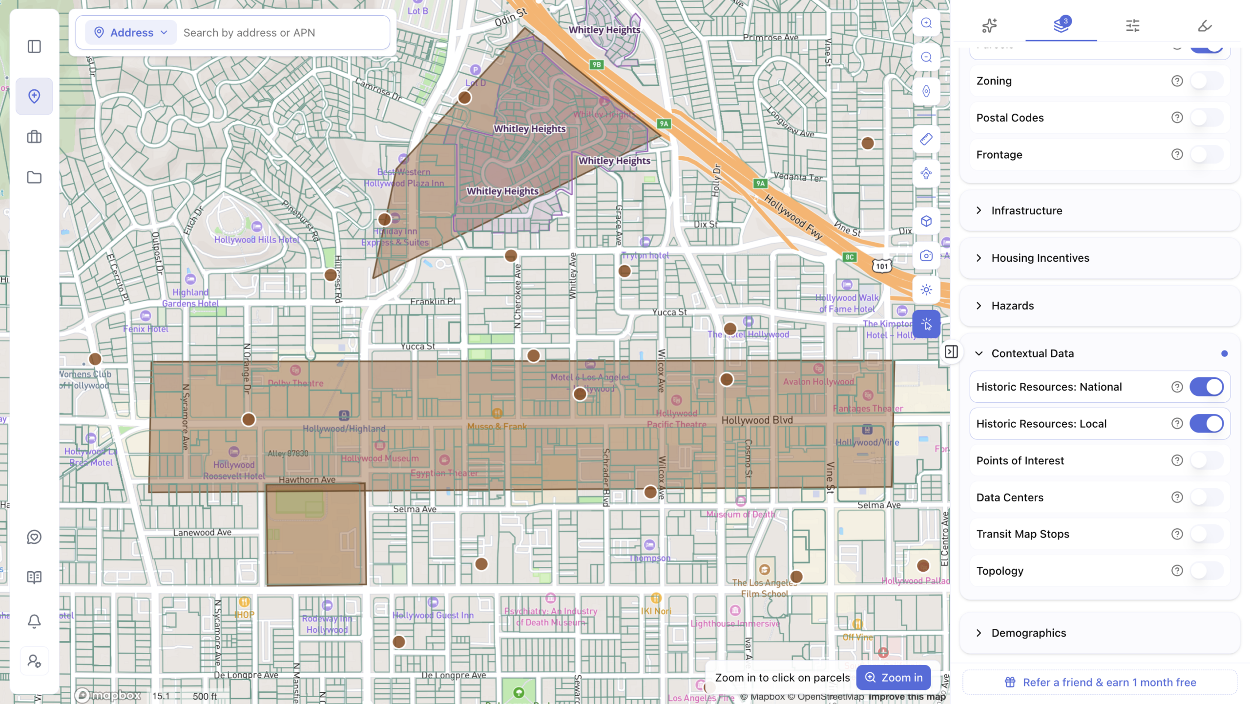
Many parcels sit inside overlay districts, which add extra requirements on top of base zoning. Think flood zones, historic districts, or transit-oriented development areas. These overlays are where deals often run into trouble, because they’re easy to miss during a manual review. AI tools automatically flag these layers so nothing slips through.
Area Intelligence
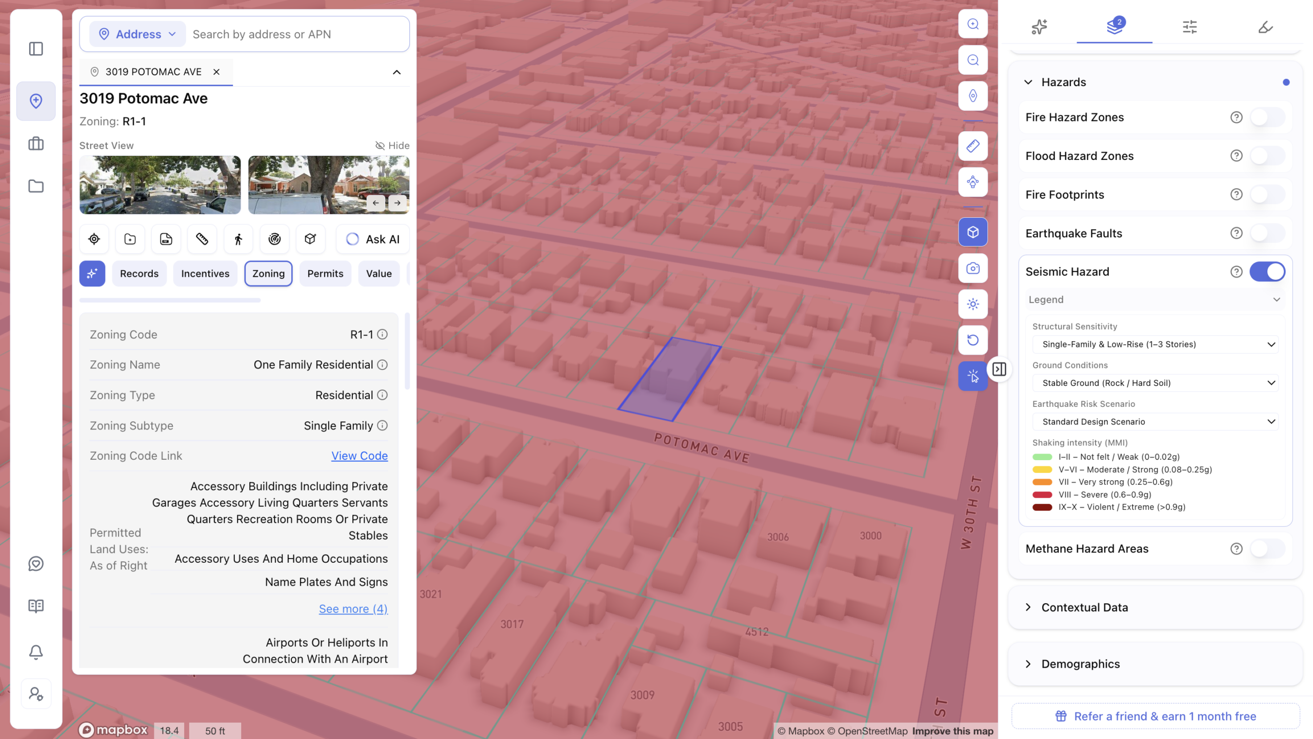
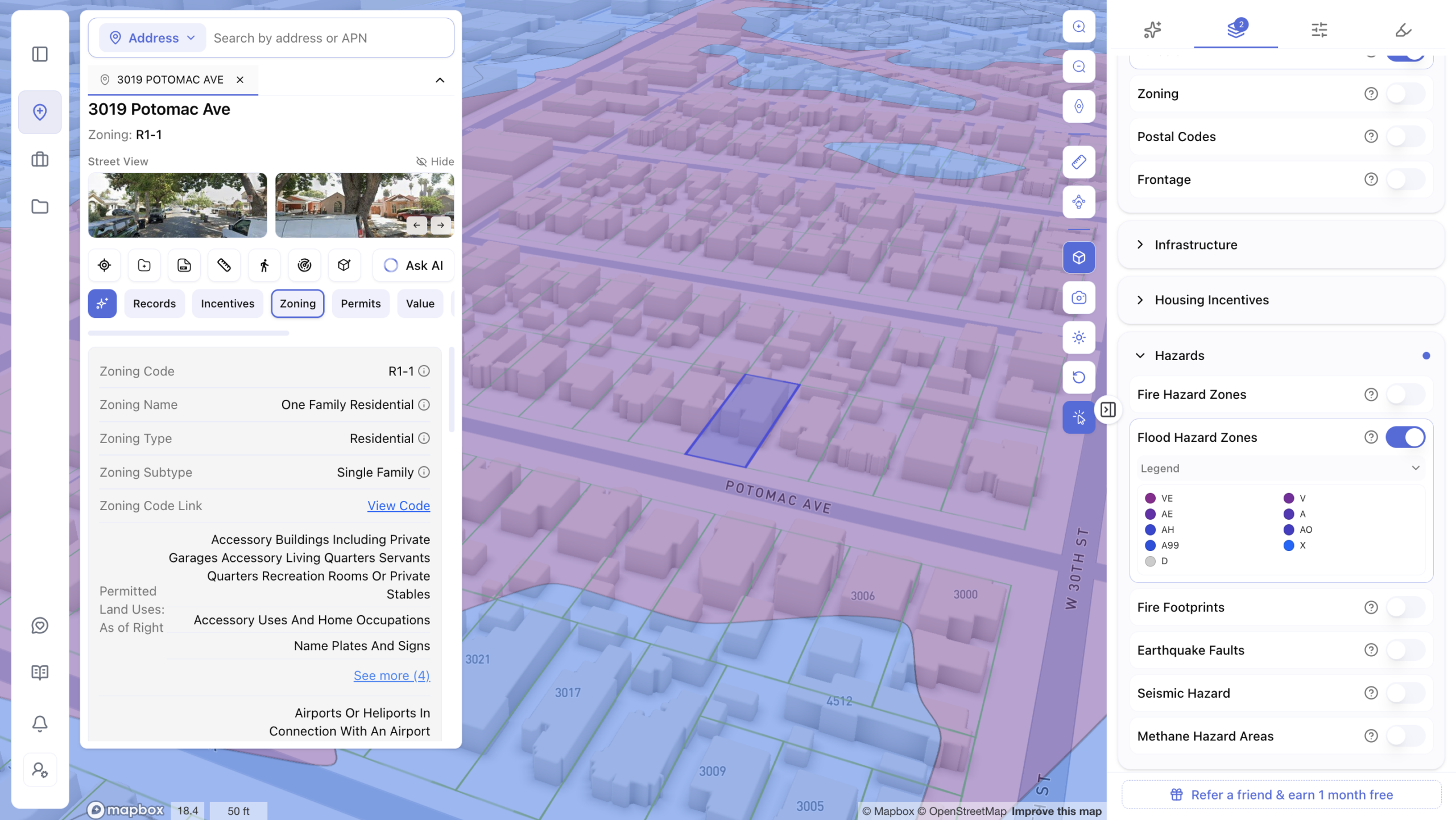
Knowing what’s legally permitted is only half the picture. The other half is understanding the conditions around the site itself. This means looking at hazards like flood or seismic risk, infrastructure capacity like water and sewer access, and demographic trends like population growth and walkability. Good land isn’t just legally buildable. It’s land that makes sense for the long term.
Feasibility and Yield Testing
Before committing to a site, developers need to test different scenarios. Different unit mixes. Different parking strategies. Different building heights. AI tools let developers run these scenarios quickly, including checking eligibility for density bonus programs that can unlock more buildable units than the base zoning suggests.
Better, Not Just Faster: Finding Land Others Miss
Speed matters, but it’s only half the story. The other half is finding opportunities other buyers never see.
The strongest AI site selection platforms are built to scan every parcel in a market, not just the ones actively listed for sale. That means developers can identify land based on zoning headroom, lot size, or other characteristics, even if the owner hasn’t thought about selling yet.
This opens the door to direct owner outreach. Instead of competing with every other buyer on the same listed properties, developers can reach out to owners of promising, unlisted land before anyone else does.
AI tools can also automatically flag density bonus programs, like those tied to affordable housing or transit-oriented development. These programs can unlock significantly more buildable units than a site’s base zoning suggests, something that’s easy to miss without specialized knowledge of local incentive programs.
Built for the Whole Deal Team
Site selection isn’t just a developer’s problem. It touches everyone on the deal.
Developers need speed and deal flow. They need to know quickly whether a site is worth pursuing, and they benefit from finding opportunities before competitors do.
Investors need consistency. When evaluating a pipeline of potential sites, they need a standardized way to compare hazards, demographics, and infrastructure across every option, not just a one-off report for a single property.
Architects need a starting point. Instead of manually working through a zoning code to figure out setbacks and height limits, AI tools can generate a 3D buildable envelope showing the maximum volume allowed on a site. That becomes the literal starting point for early massing studies. (Note: exporting these envelopes as CAD files is typically available on higher-tier plans, so check what’s included before relying on it.)
The real value here is that one underlying analysis can serve the entire team, instead of three separate efforts: a broker’s zoning summary, a consultant’s feasibility study, and an architect’s own manual code review.
How ArchiWise Puts This Into Practice
This is exactly the gap ArchiWise was built to close.
ArchiWise is an AI decision platform for real estate pre-development. It covers over 19,000 U.S. cities and more than 155 million parcels, representing over 90% of U.S. development activity, according to ArchiWise. The company reports that its zoning data is checked against professional consultant reports and reaches 99.2% accuracy, with code updates reflected within 24 to 48 hours of being published.
Using it is simple. A developer can type a plain-English question, like what can be built on a specific address, and get an instant answer with the underlying code cited. From there, they can compare multiple sites side by side before deciding where to focus.
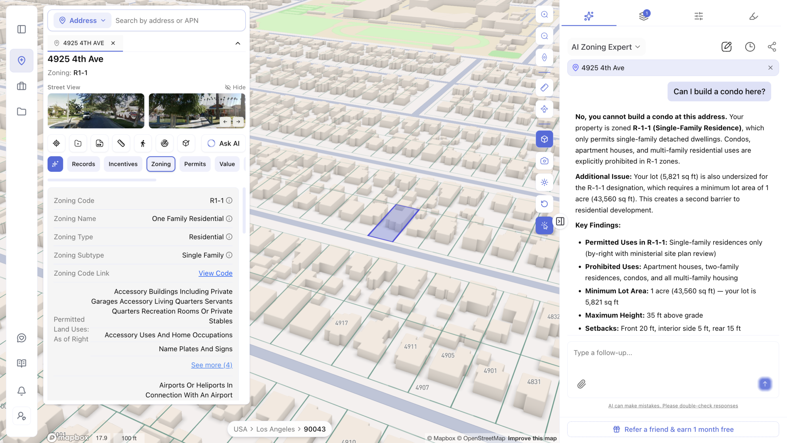
ArchiWise customers have described real-world moments where the platform caught a zoning issue, like a hidden overlay restriction, before it became a costly problem later in the process. These are individual customer experiences, not guaranteed outcomes for every deal, but they show what the technology is designed to catch.
No GIS background or technical training is required to use it. If you’ve used Google Maps, you can use ArchiWise.
Frequently Asked Questions
How do I check zoning for a property? You can check with your local planning department, search public GIS records, or use an AI platform that pulls zoning data directly from official municipal sources for a specific address.
What can I build on my property? This depends on your zoning designation, lot size, and any overlay restrictions that may apply. It typically includes rules on use type, height, setbacks, and density.
What is pre-development in real estate? Pre-development is the research phase before a developer commits capital to a site. It includes zoning analysis, feasibility testing, and risk review to confirm a project is viable before moving forward.
Better Sites, Faster Decisions
The developers winning the best deals right now aren’t necessarily finding secret land nobody else knows about. They’re simply deciding faster, with more confidence, on the land everyone can see.
Stop losing good deals to slow research. Every week you spend digging through zoning PDFs is a week a competitor spends closing on the site you wanted. Try ArchiWise free and run your first zoning and feasibility analysis in minutes, not weeks. No credit card, no GIS degree, no excuses.
Learn more
ArchiWise helps developers, investors, architects, and brokers go from address to decision in minutes, not weeks.
Whether you’re screening sites for multifamily development, evaluating zoning constraints, surfacing incentive eligibility like QCT and LIHTC, or assessing hazard risk before committing capital, ArchiWise runs every layer of analysis in one place.
Explore how ArchiWise helps teams screen development sites, analyze zoning, and make confident go/no-go decisions faster.