
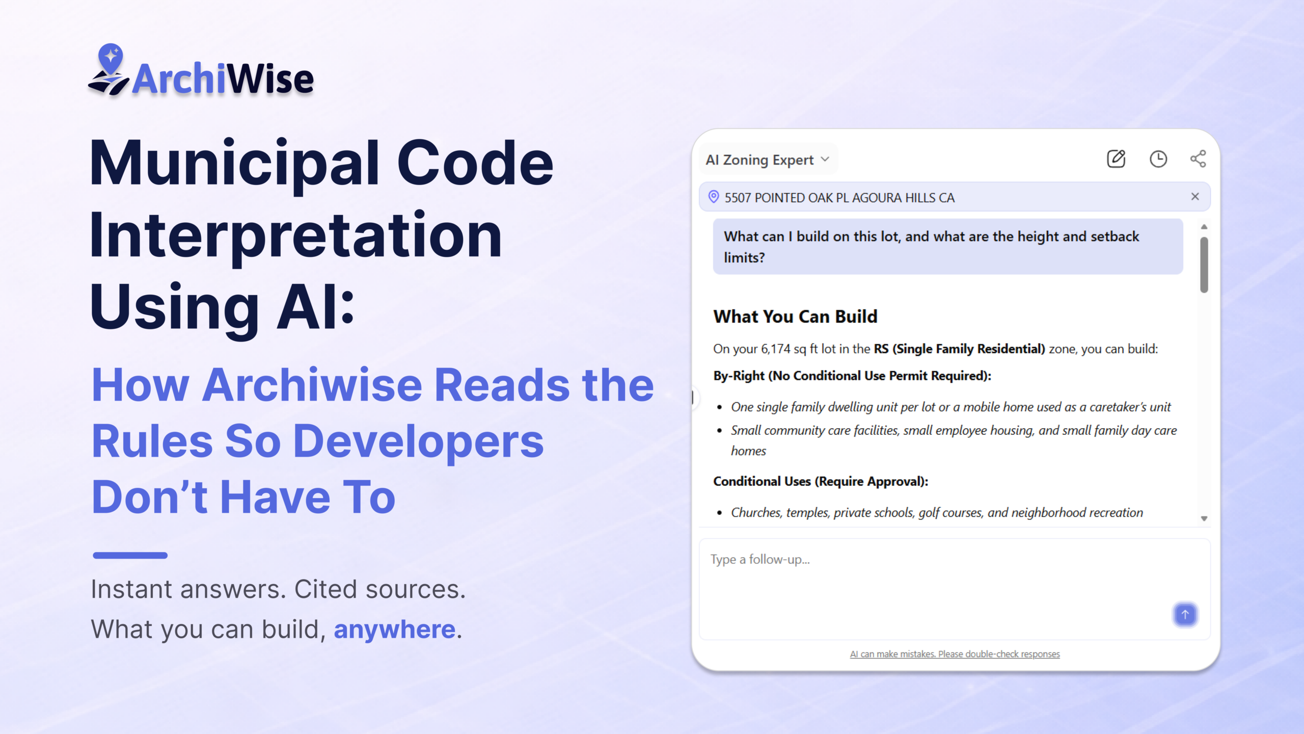

The single document that decides what you’re allowed to build – and why reading it has always been the hardest part of the job.
Before a lender looks at your pro forma. Before an architect draws a single line. Before you even decide whether a site is worth an offer – one document has already decided what’s possible on that parcel: the municipal code.
It tells you what you’re allowed to build. How many units fit on the lot. How tall the building can go. How far it has to sit from the property line. Whether the use you have in mind is permitted outright, permitted with approval, or not permitted at all. Skip it, and everything that comes after – the design, the underwriting, the offer – is built on a guess.
That’s not an exaggeration. A project designed for three stories on a site capped at two doesn’t get value-engineered back into shape. It gets redesigned, or it gets abandoned. A unit count that assumes standard density on a lot with a [Q] condition capping it lower doesn’t just miss the mark on returns – it can miss it after the purchase agreement is signed.
What Municipal Code Actually Decides
Every one of the basic questions a developer needs answered lives inside the code:
- What can be built here by right, and what needs a conditional use permit or a variance?
- What’s the maximum density, floor area ratio, and height?
- What are the setback and parking requirements?
- Which uses are prohibited outright – the ones that quietly kill a concept before it starts?
None of this is optional reading. It’s the actual rulebook the planning department will hold your application against. Get it right early, and you’re designing toward something achievable. Get it wrong, and you find out in plan check, months into a project, when it’s expensive to fix.
Reading It Is a Different Skill Than Understanding It
Here’s the part that trips up even experienced developers: having access to the code isn’t the same as being able to use it.
Municipal codes are long, cross-referenced, and written in a register that assumes the reader is a planner or an attorney, not someone trying to close a deal. A single zoning designation can be shorthand for several stacked layers – a base zone, a height district, an overlay, sometimes a [Q] condition – and each of those layers points to its own section, its own exceptions, its own definitions elsewhere in the code. Reading one designation correctly can mean flipping between several parts of a document that was never written to be read in one sitting.
And it’s not one code. It’s hundreds of them, each different. A zoning letter that means one thing in Los Angeles means something else in Houston, or means nothing at all, because the jurisdiction doesn’t use that system. A developer working across a handful of markets isn’t just checking numbers – they’re relearning the rules from scratch every time the city changes.
For example, take a parcel at 5507 Pointed Oak Pl in Agoura Hills, California, zoned RS. The name alone – “Single Family Residential” – suggests a simple answer. It isn’t one. The code splits RS into six numbered subcategories, RS-2 through RS-6, each carrying its own minimum lot area, from 15,000 sq ft down to 6,000 sq ft. On top of that, nearly every dimensional standard – setbacks, lot width, lot depth, lot coverage – is split again by whether the specific lot falls above or below 10,000 sq ft. Reading “RS” off a zoning map tells you almost nothing until you know which subcategory applies and which size tier the parcel falls into.
This is why municipal code research has historically been slow, why it’s usually handed to whoever has the most patience for it, and why mistakes happen even when everyone involved is competent. It’s not a knowledge problem. It’s a time and complexity problem.
Archiwise: Municipal Code, Answered Instantly
This is exactly the gap the AI Zoning Expert in Archiwise was built to close.
Plenty of platforms will show you a parcel’s zoning – the designation, the overlay, maybe a link to the ordinance. That’s a real improvement over a county portal, but it’s still just data on a screen; you still have to read it and work out what it means for your project. Most of that underlying data is already public. Archiwise’s advantage isn’t access to it. It’s interpretation – the AI Zoning Expert reads the applicable code the way a planner would and gives you the answer, not just the source material.
Instead of opening the code yourself, finding the right section, and working through what it means for your specific parcel, you just ask. What’s permitted by right. What needs a conditional use permit. What the maximum density, height, or setbacks are. Whether the site qualifies for an incentive program. Whatever the question, the AI Zoning Expert answers immediately – and what you get back is not a guess: a plain-language answer with the exact code section cited, so you can verify it yourself.
Take that same parcel from the RS example above. Start simple:“What can I build on this lot, and what are the height and setback limits?”
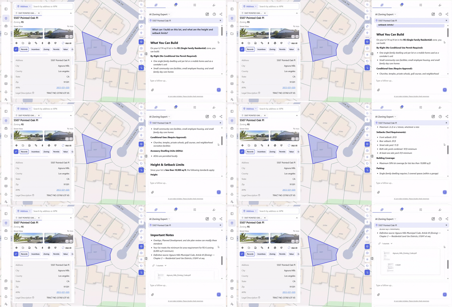
The real change isn’t just speed, although going from hours of code-reading to a few seconds of typing matters on its own. It’s that the answer isn’t a general description of what a zone “typically” allows. For this parcel, the by-right answer comes back narrow: one single-family dwelling unit per lot, or a mobile home used as a caretaker’s unit, plus small-scale uses like community care facilities, employee housing, and family day care homes. Churches, private schools, golf courses, and neighborhood recreation facilities are allowed too – but only with a conditional use approval. ADUs are permitted locally.
Since the lot is under 10,000 sq ft, height tops out at 35 ft or two stories, whichever is less; setbacks run 20 ft front and rear, 15 ft on the street side, with side yards totaling at least 18 ft combined and at least 8 ft on one side; lot coverage is capped at 50%; and a single-family dwelling requires two covered parking spaces. The answer even flags where it could still move: overlays, planned development, and site-plan review can modify these standards. Every figure traces back to a real citation: Agoura Hills Municipal Code, Article IX (Zoning), Chapter 2 – Residential Land Use Districts, § 9241 et seq.
That’s enough to screen a site in seconds. But the AI Zoning Expert works like an actual conversation – when the answer raises a more specific question, you go deeper in the same thread. For this parcel, a natural next question pulled straight from the municipal code would be:
“What’s the maximum number of units I can build, and does this lot qualify for an ADU?”
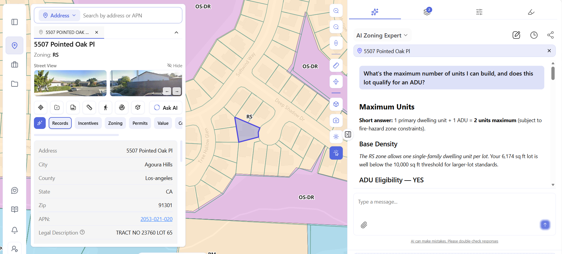
The answer comes back direct: 1 primary dwelling unit + 1 ADU = 2 units maximum, subject to fire-hazard zone constraints. The base density explanation ties straight back to the same RS standards from the first question – one single-family dwelling unit per lot, since the 6,174 sq ft lot falls well below the 10,000 sq ft threshold that would trigger the larger-lot standards. And on the specific follow-up: ADU eligibility – yes.
Worth noting in this screenshot too: the map on the left has the Zoning layer turned on, so the color-coded districts around the parcel – the tan RS area the lot sits in, the surrounding OS-DR open-space zones – are visible at a glance, without opening a single tab.
Both are real answers to real questions, sourced back to the exact code sections a developer – or their attorney – can pull up and confirm. No separate lookup. No decoding the zoning designation by hand. No waiting on a planner’s callback.
Agoura Hills is just one example. Nothing about this is specific to that city or that zone. The same question, asked on a parcel in Chicago, Austin, or Sacramento, gets answered the same way – drawn from that jurisdiction’s own zoning code, cited the same way. The workflow doesn’t change from one city to the next. Only the answer does, because the underlying code does.
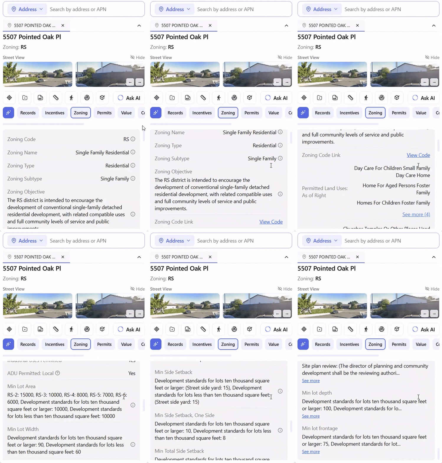
Every parcel’s info modal also includes a dedicated Zoning tab laying out that same underlying data for reference – the zoning code, permitted uses, and dimensional standards, all in one place. It’s not a substitute for asking, but it’s useful when you just want the numbers in front of you without typing a question first.
 Beyond the Municipal Code
Here’s the catch even a perfect municipal code answer runs into: it’s rarely the whole story. The code sets the baseline for a parcel – it’s rarely the only document governing it.
The municipal code sets the baseline. It’s rarely the whole story.
Most sites are also governed by documents that sit alongside the zoning code – a specific plan for that neighborhood, a community plan, a general plan policy, an overlay ordinance, or a state law like a density bonus statute that can override local zoning entirely. A parcel’s real development potential is whatever you get when all of these are read together, not just the base code in isolation. Miss the specific plan, and you might think a site is more – or less – restricted than it actually is.
This is why Archiwise’s AI Zoning Expert doesn’t stop at the municipal code. For every city, county, and state it covers, it draws on the full set of official planning documents that actually govern a parcel – zoning codes, general plans, specific plans, community plans, overlay ordinances, and applicable state legislation – the same body of documents a planning department itself would reference. When a specific plan changes what the base zone would otherwise allow, that’s reflected in the answer, with its own citation.
That’s the difference between a tool that tells you the zone, and one that tells you what you can actually build.
The Bottom Line
Municipal code was never going to get shorter or easier to read. What’s changed is how fast you can get a straight answer out of it. Ask a plain-language question, get back exactly what the code says for that parcel – cited, verifiable, in seconds instead of days. That’s not a shortcut around the rules. It’s just a faster way to know them.
Stop guessing what you can build. Ask Archiwise
Get a straight answer on any parcel – sourced from the actual code that governs it.
Learn more
ArchiWise helps developers, investors, architects, and brokers go from address to decision in minutes, not weeks.
Whether you’re screening sites for multifamily development, evaluating zoning constraints, surfacing incentive eligibility like QCT and LIHTC, or assessing hazard risk before committing capital, ArchiWise runs every layer of analysis in one place.
Explore how ArchiWise helps teams screen development sites, analyze zoning, and make confident go/no-go decisions faster.